Laojieling Scenic Area is located in the north of Xixia County, Nanyang City, Henan Province. It is a national 5A-level tourist attraction and the core area of a UNESCO Global Geopark. The scenic area covers a total area of about 230,000 mu. Its main peak, Jijiaojian, has an elevation of 2,212.5 meters, making it the main peak and highest point of the Funiu Mountains. It is known as "the supreme summit of the 800-li Funiu Mountains." Laojieling lies at the watershed between the Yangtze River and the Yellow River and is a transitional climate zone between northern and southern China. It is famous for its four major natural landscapes: "peculiar peaks, sea of clouds, sunrise, and forest sea," and is hailed as "the backbone of the Chinese land."
History and Culture
Laojieling was formed about 800 million years ago in the Neoproterozoic Era and is the eastern extension of the Qinling orogenic belt. In 2006, as the core scenic area of the Funiu Mountain UNESCO Global Geopark, it was inscribed on the UNESCO Global Geoparks list.
The scenic area preserves numerous historical relics, including the Chu Great Wall site from the Warring States Period and the Yunyan Temple from the Tang Dynasty. Legend has it that Laozi once lectured here, and there are Taoist cultural relics such as the "Laojun Terrace" in the mountains.
Laojieling is also an old revolutionary base area. During the War of Resistance Against Japanese Aggression, the Western Henan Anti-Japanese Advance Detachment established a base area here, and many revolutionary sites remain.
Main Attractions
Jijiaojian
Jijiaojian is the main peak of Laojieling, with an elevation of 2,212.5 meters. Standing on the summit, visitors can "stand in two cities with one foot and view three counties at a glance." A viewing platform is built at the top, making it the best place to watch the sea of clouds and sunrise. On clear days, one can overlook the two major river systems of the Yellow River and the Yangtze River.
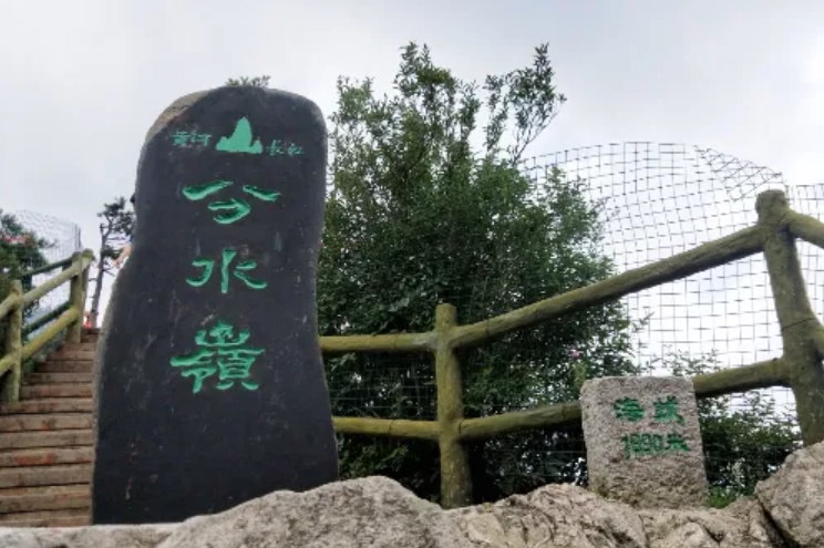
Watershed
This is the location of the watershed between the Yangtze River and the Yellow River, marked by a watershed monument. The ridge line here is clear. Water on the northern slope flows into the Yellow River, while water on the southern slope flows into the Yangtze River, making it a unique geographical wonder.
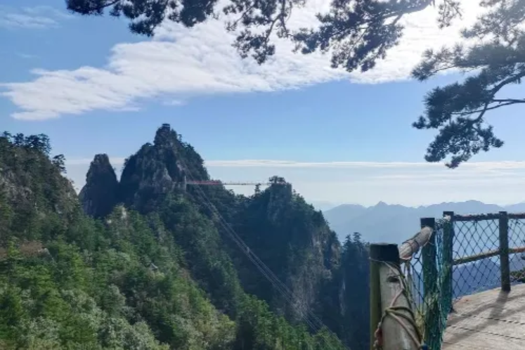
Xianren Peak
A group of strangely shaped stone peaks, the highest of which resembles an immortal pointing the way, hence the name. The peak forest is shrouded in mist and clouds, like a fairyland, making it an ideal shooting location for photography enthusiasts.
Grand Sea of Clouds
Laojieling has more than 200 days of cloud sea on average each year, with the most spectacular views in summer and autumn. When the sea of clouds appears, the peaks loom faintly amid the rolling clouds, like immortal mountains on the sea.
Primeval Forest
A well-preserved primeval forest ecosystem with a forest coverage rate of over 98%, known as a "natural oxygen bar." Ancient trees tower in the forest, including rare tree species such as yew and ginkgo.
Tour Route:
Recommended tour route: Scenic Area Entrance → Take the sightseeing bus to the cableway station → Take the cableway up the mountain → Watershed → Xianren Peak → Jijiaojian (watch the sea of clouds and sunrise) → Primeval Forest → Return. Visitors in good physical condition may choose to hike up the mountain.
Travel Tips:
It is recommended to arrange 1-2 days. Staying at the summit allows you to watch the sunrise and sea of clouds.
Wear non-slip sports shoes for hiking and bring trekking poles.
Mountain weather changes frequently, so bring rain gear and warm clothing.
Photography enthusiasts may bring wide-angle lenses and tripods.
Protect the ecological environment. Do not pick plants or catch animals.
Book summit accommodation in advance during peak season (beds are limited).
Precautions:
Some sections are steep. Pay attention to safety and do not approach cliffs.
Protect the ecological environment and do not litter.
Observe scenic area regulations and do not enter unopened areas.
People with heart disease or high blood pressure should avoid strenuous exercise.
In case of thunderstorms, mountaineering activities should be suspended.
The signal in the scenic area is weak. Inform family members of your itinerary in advance.
Transportation:
Self-driving: From the direction of Zhengzhou, take the Zheng-Luan Expressway to Xixia Station, exit, and drive north along National Highway 311 for about 30 kilometers.
Bus: There are direct tourist shuttle buses to the scenic area from Nanyang Bus Station.
High-speed rail: Take the high-speed rail to Nanyang East Station, then transfer to the scenic area shuttle bus, which takes about 2 hours.
Airplane: The nearest airport is Nanyang Jiangying Airport, about 2.5 hours' drive from the scenic area.
Opening Hours:
The scenic area is open all year round. Opening hours are 7:00-18:00 (peak season) and 8:00-17:00 (off-season). A full tour takes about 4-6 hours. It is recommended to reserve a full day.
Tickets:
Ticket: 100 yuan per person (including sightseeing bus).